Inventory Search Results
17 suspension bridges were found for search criteria: HAERTX98. All 17 bridges from the search results appear below. Click the Bridgemeister ID number to isolate the bridge on its own page. If you don't see what you were looking for, try an image search with the same criteria: HAERTX98. This will find the bridge if it is pictured on the site, but is not a catenary suspension bridge.
Related:
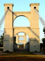
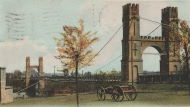
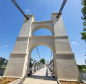
1869: Waco
Waco, Texas, USA - Brazos River
| Bridgemeister ID: | 72 (added before 2003) |
| Year Completed: | 1869 |
| Name: | Waco |
| Location: | Waco, Texas, USA |
| Crossing: | Brazos River |
| Coordinates: | 31.561314 N 97.127063 W |
| Maps: | Acme, GeoHack, Google, OpenStreetMap |
| Principals: | Thomas M. Griffith |
| References: | AAJ, BC3, BPL, BRAZ, GBD, HAERTX98, HBE, PTS2, WSB |
| Use: | Vehicular, with walkway |
| Status: | Restricted to foot traffic (last checked: 2023) |
| Main Cables: | Wire (iron) |
| Suspended Spans: | 1 |
| Main Span: | 1 x 144.8 meters (475 feet) |
| Deck width: | 18 feet |
Notes:
- 1915: Rebuilt.
- 2020, October: Closed for restoration project expecting to last 18-24 months.
- 2021, March: Major restoration project underway, led by Sparks Engineering, Inc.
- 2023, April: The restored bridge is rededicated on April 22. Patrick Sparks of Sparks Engineering reports: . The rededication was held April 22, 2023. "The project involved full rehabilitation including: replacement of the suspension system and anchor rods, strengthening of the anchorages, replacement of the saddle bearings, retrofit strengthening of the east tower, and deck replacement (concrete on the main deck, tropical hardwood on the side walks)."
External Links:
1896: Beveridge
San Saba, Texas, USA - San Saba River
| Bridgemeister ID: | 102 (added before 2003) |
| Year Completed: | 1896 |
| Name: | Beveridge |
| Location: | San Saba, Texas, USA |
| Crossing: | San Saba River |
| Coordinates: | 31.21083 N 98.74083 W |
| Maps: | Acme, GeoHack, Google, OpenStreetMap |
| Principals: | Flinn-Moyer Co. |
| References: | HAERTX98 |
| Use: | Vehicular (one-lane) |
| Status: | Restricted to foot traffic (last checked: 2008) |
| Main Cables: | Wire |
| Suspended Spans: | 1 |
Notes:
- Located near the locally famous Wedding Oak tree.
- 1938: Reconstructed by Austin Bridge Co.
- 2006: Major restoration project completed.
External Links:
- Beveridge Bridge Restoration Project - YouTube. A 27-minute video.
- Structurae - Structure ID 20005565
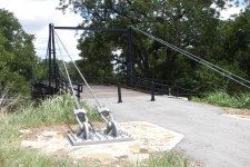
1896: Clear Fork Of The Brazos
Woodson vicinity, Shackelford County, Texas, USA - Clear Fork Brazos River
| Bridgemeister ID: | 103 (added before 2003) |
| Year Completed: | 1896 |
| Name: | Clear Fork Of The Brazos |
| Location: | Woodson vicinity, Shackelford County, Texas, USA |
| Crossing: | Clear Fork Brazos River |
| Coordinates: | 32.921611 N 99.167944 W |
| Maps: | Acme, GeoHack, Google, OpenStreetMap |
| Principals: | Flinn-Moyer Co. |
| References: | BRAZ, HAERTX64, HAERTX98 |
| Use: | Vehicular |
| Status: | Extant (last checked: 2019) |
| Main Cables: | Wire |
| Suspended Spans: | 1 |
External Links:

1904: Brazos
Brazos, Texas, USA - Brazos River
| Bridgemeister ID: | 1857 (added 2005-07-17) |
| Year Completed: | 1904 |
| Name: | Brazos |
| Location: | Brazos, Texas, USA |
| Crossing: | Brazos River |
| Principals: | William Flinn |
| References: | HAERTX98 |
| Use: | Vehicular |
| Status: | Removed |
| Main Cables: | Wire |
| Suspended Spans: | 3 |
| Main Span: | 1 x 91.4 meters (300 feet) |
| Side Spans: | 2 x 45.7 meters (150 feet) |
1904: Dark Valley
Graford and Palo Pinto, Texas, USA - Brazos River
| Bridgemeister ID: | 921 (added 2003-10-18) |
| Year Completed: | 1904 |
| Name: | Dark Valley |
| Location: | Graford and Palo Pinto, Texas, USA |
| Crossing: | Brazos River |
| Principals: | William Flinn |
| References: | BRAZ, HAERTX98 |
| Use: | Vehicular |
| Status: | Demolished, 1958 |
| Main Cables: | Wire (steel) |
| Suspended Spans: | 5 |
| Main Spans: | 2 x 76.2 meters (250 feet) |
| Side Spans: | 1 x 24.4 meters (80 feet), 2 x 38.1 meters (125 feet) |
| Deck width: | 16 feet |
Notes:
- The TxDOT Bridge Division website shows an image of this bridge with caption "The Dark Valley Bridge is shown here before its demolition in 1958," but BRAZ describes it as being destroyed by a flood on October 31, 1981. The TxDOT information is likely correct.
1906: Brannon's Crossing
Weatherford vicinity, Parker County, Texas, USA - Brazos River
| Bridgemeister ID: | 1298 (added 2004-03-28) |
| Year Completed: | 1906 |
| Name: | Brannon's Crossing |
| Location: | Weatherford vicinity, Parker County, Texas, USA |
| Crossing: | Brazos River |
| Coordinates: | 32.66256 N 98.03288 W |
| Maps: | Acme, GeoHack, Google, OpenStreetMap |
| Principals: | Mitchell & Pigg |
| References: | HAERTX98 |
| Use: | Vehicular |
| Status: | Replaced, 1934 |
| Main Cables: | Wire (steel) |
| Main Span: | 1 x 134.1 meters (440 feet) |
Notes:
- Tony King believes he found the former location of this bridge a few hundred yards south of the I-20 Brazos River crossing west of Weatherford. This location is near a road named "Brannon Bridge Circle." Tony writes: "Just downstream from the modern Interstate 20 bridge in western Parker County, I've noticed a concrete and iron structure, and happened to take a photo of it recently. I've noticed the structure a couple of times in the past (most recently in May of 2007) while hiking a well-worn foot/ATV path that parallels the west bank of the river as it flows almost due south from the Interstate to Meeks Bend." The structure in Tony's photo appears to be a pier or support footing. The coordinates given here are Tony's approximation of the location of the structure.
- Built as part of the same contract as the Tin Top bridge.
- Similar to 1906 Tin Top (Hightower Valley) - Tin Top, Texas, USA.
1906: Tin Top
Tin Top, Texas, USA - Brazos River
| Bridgemeister ID: | 119 (added before 2003) |
| Year Completed: | 1906 |
| Name: | Tin Top |
| Also Known As: | Hightower Valley |
| Location: | Tin Top, Texas, USA |
| Crossing: | Brazos River |
| Coordinates: | 32.575956 N 97.822697 W |
| Maps: | Acme, GeoHack, Google, OpenStreetMap |
| Principals: | Mitchell & Pigg |
| References: | BRAZ, HAERTX98 |
| Use: | Vehicular |
| Status: | Collapsed, Jan. 31, 1982 under weight of snow |
| Main Cables: | Wire (steel) |
| Main Span: | 1 x 121.9 meters (400 feet) |
Notes:
- Some internet resources suggest the "Tin Top" and "Hightower" suspension bridges were separate nearby structures, however, this does not appear to have been the case. Both names were used to describe the same structure and USGS topographical maps from the 1950s label the bridge due south of Tin Top as "Hightower". Mitchell and Pigg did build a similar structure, at Brannon's Crossing. The 2015 National Register of Historic Places Registration Form for "Historic Road Infrastructure of Texas, 1866-1965", the Texas Department of Transportation writes: "In 1905 [Mitchell and Pigg] constructed the practically identical Brannon's Crossing and Hightower Valley Bridges across the Brazos in Parker County. The former was a 440-foot clear span while the later, also known as Tin Top, was 400 feet."
- The coordinates appear to be the exact location of a pier remaining (as of 2020) from this bridge. The alignment indicated by the pier appears to exactly match the location of this bridge as indicated by 1958 USGS topographical map of the area.
- Similar to 1906 Brannon's Crossing - Weatherford vicinity, Parker County, Texas, USA.
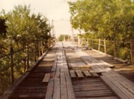
1908: Newcastle
Newcastle, Texas, USA - Brazos River
| Bridgemeister ID: | 1299 (added 2004-03-28) |
| Year Completed: | 1908 |
| Name: | Newcastle |
| Location: | Newcastle, Texas, USA |
| Crossing: | Brazos River |
| Principals: | Mitchell & Pigg |
| References: | HAERTX98 |
| Use: | Vehicular |
| Status: | Collapsed, 1930 |
| Main Cables: | Wire (steel) |
| Suspended Spans: | 3 |
| Main Span: | 1 x 213.4 meters (700 feet) |
| Side Spans: | 2 |
Notes:
- Collapsed during flood, 1930.
1908: South Bend
South Bend, Texas, USA - Brazos River
| Bridgemeister ID: | 1858 (added 2005-07-17) |
| Year Completed: | 1908 |
| Name: | South Bend |
| Location: | South Bend, Texas, USA |
| Crossing: | Brazos River |
| Principals: | Mitchell & Pigg |
| References: | HAERTX98 |
| Use: | Vehicular |
| Status: | Removed |
| Main Cables: | Wire |
| Main Span: | 1 x 121.9 meters (400 feet) |
| Bridgemeister ID: | 600 (added 2003-01-11) |
| Year Completed: | 1914 |
| Name: | 98th Meridian |
| Also Known As: | Byers |
| Location: | Byers, Texas and Temple, Oklahoma, USA |
| Crossing: | Red River |
| Coordinates: | 34.124507 N 98.214251 W |
| Maps: | Acme, GeoHack, Google, OpenStreetMap |
| Principals: | Mitchell & Pigg |
| References: | AUB, HAERTX98, PTS2 |
| Use: | Vehicular |
| Status: | Destroyed, 1923 |
| Main Cables: | Wire (steel) |
| Suspended Spans: | 4 |
| Main Spans: | 3 x 172.8 meters (567 feet) |
| Side Span: | 1 x 32.6 meters (107 feet) |
Notes:
- Destroyed by tornado, 1923.
- Coordinates are the exact location of one of the remaining (as of 2020) piers of either this bridge or its replacement suspension bridge. Additional piers, south of that location, are also visible in satellite images.
- Replaced by 1923 98th Meridian (Byers) - Byers vicinity, Texas and Temple, Oklahoma, USA.
- See (suspension bridge) - Texas, USA. The 98th Meridian bridge may match this unknown "Red River" bridge photo. AUB describes the Byers bridge, "This bridge, three spans of 567' each, one side span of 107', and a 16' roadway, had originally been built in 1914."
1917: Rock Church
Tolar vicinity, Hood County, Texas, USA - Paluxy River
| Bridgemeister ID: | 136 (added before 2003) |
| Year Completed: | 1917 |
| Name: | Rock Church |
| Location: | Tolar vicinity, Hood County, Texas, USA |
| Crossing: | Paluxy River |
| Coordinates: | 32.301402 N 97.957657 W |
| Maps: | Acme, GeoHack, Google, OpenStreetMap |
| References: | HAERTX98 |
| Use: | Vehicular (one-lane) |
| Status: | Extant (last checked: 2018) |
| Main Cables: | Wire |
| Suspended Spans: | 1 |
External Links:
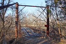
| Bridgemeister ID: | 140 (added before 2003) |
| Year Completed: | 1924 |
| Name: | Nocona |
| Also Known As: | Bluff, Ketchum Bluff, Ketchum's Bluff |
| Location: | Nocona vicinity, Texas and Jefferson County, Oklahoma, USA |
| Crossing: | Red River |
| At or Near Feature: | Ketchum Bluff |
| Coordinates: | 33.93579 N 97.75869 W |
| Maps: | Acme, GeoHack, Google, OpenStreetMap |
| Principals: | Austin Bridge Co. |
| References: | AUB, HAERTX98, PTS2 |
| Use: | Vehicular |
| Status: | Only towers remain (last checked: 2007) |
| Main Cables: | Wire (steel) |
| Main Span: | 1 x 213.4 meters (700 feet) |
Notes:
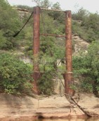
- Legend has it the bridge was burned during a dispute. This likely occurred before 1955. Some sources suggest it occurred before or during 1950. The road that leads to the Texas side of the former crossing is "Burned Out Bridge Road." Follow the image of the derelict tower to see the remains of the bridge.
- AUB mentions: "In January 1924, a contract was entered into with Nocona Bridge Company for a bridge across Red River, nine miles north of Nocona, connecting Texas and Oklahoma. The plans called for a 700' span, 16' roadway, and the main cables to contain 1,000 No. 9 galvanized wires each. The building of this, [the Austin Bridge Company's] first complete cable bridge, and the experience gained therefrom helped to launch Austin Bridge Company into an interesting and profitable line of work."
External Links:
- Nocona Suspension Bridge at Ketchum Bluff, Texas. University of Texas Arlington Libraries Digital Gallery
1926: Hidalgo-Reynosa International
Hidalgo, Texas, USA and Reynosa, Tamaulipas, Mexico - Rio Grande
| Bridgemeister ID: | 146 (added before 2003) |
| Year Completed: | 1926 |
| Name: | Hidalgo-Reynosa International |
| Location: | Hidalgo, Texas, USA and Reynosa, Tamaulipas, Mexico |
| Crossing: | Rio Grande |
| Principals: | Austin Bridge Co. |
| References: | AAJ, AUB, HAERTX98, PTS2 |
| Use: | Vehicular |
| Status: | Demolished, 1960's |
| Main Cables: | Wire (steel) |
| Suspended Spans: | 1 |
| Main Span: | 1 x 137.2 meters (450 feet) |
Notes:
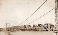
- Damaged by flood, 1933. Rebuilt, 1934. Cables failed, 1939. Rebuilt.
1928: (suspension bridge)
Rio Rico, Mexico and Mercedes, Texas, USA - Rio Grande
1928: Roma-Miguel Alemán International
Roma, Texas, USA and Ciudad Miguel Alemán, Mexico - Rio Grande
| Bridgemeister ID: | 157 (added before 2003) |
| Year Completed: | 1928 |
| Name: | Roma-Miguel Alemán International |
| Also Known As: | Roma-San Pedro International |
| Location: | Roma, Texas, USA and Ciudad Miguel Alemán, Mexico |
| Crossing: | Rio Grande |
| Coordinates: | 26.403821 N 99.018856 W |
| Maps: | Acme, GeoHack, Google, OpenStreetMap |
| Principals: | George Cole, Starr County Bridge Co., Compañía del Puente de San Pedro de Roma |
| References: | HAERTX98, PTS2 |
| Use: | Vehicular |
| Status: | Closed, 1979 (last checked: 2023) |
| Main Cables: | Wire (steel) |
| Suspended Spans: | 1 |
| Main Span: | 1 x 192 meters (629.9 feet) |
| Deck width: | 6.9 meters |
Notes:
- Closed. Scheduled to be restored as pedestrian crossing.
External Links:
1928: Zapata
Zapata, Texas, USA and Ciudad Guerrero, Mexico - Rio Grande
| Bridgemeister ID: | 1445 (added 2004-07-31) |
| Year Completed: | 1928 |
| Name: | Zapata |
| Location: | Zapata, Texas, USA and Ciudad Guerrero, Mexico |
| Crossing: | Rio Grande |
| References: | HAERTX98, PTS2 |
| Use: | Vehicular |
| Status: | Inundated, 1953 |
| Main Cables: | Wire (steel) |
| Suspended Spans: | 3 |
| Main Span: | 1 x 165 meters (541.3 feet) |
| Side Spans: | 2 |
Notes:
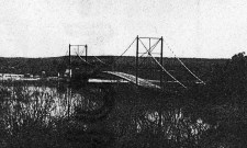
- Inundated during creation of Falcon Reservoir.
Choctaw Creek
Bells vicinity, Grayson County, Texas, USA - Choctaw Creek
| Bridgemeister ID: | 133 (added before 2003) |
| Name: | Choctaw Creek |
| Location: | Bells vicinity, Grayson County, Texas, USA |
| Crossing: | Choctaw Creek |
| Coordinates: | 33.650717 N 96.480981 W |
| Maps: | Acme, GeoHack, Google, OpenStreetMap |
| Principals: | William H. C. Greer |
| References: | HAERTX98 |
| Use: | Vehicular (one-lane) |
| Status: | Derelict (last checked: 2018) |
| Main Cables: | Wire |
| Suspended Spans: | 1 |
Notes:
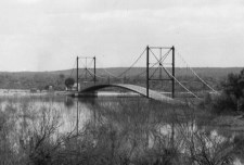
- Likely built in the 1910s.
