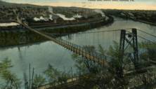
This is a single suspension bridge from the Bridgemeister historical inventory of suspension bridges.
1886: Lower
Easton, Pennsylvania, USA - Lehigh River
| Bridgemeister ID: | 813 (added 2003-05-29) |
| Year Completed: | 1886 |
| Name: | Lower |
| Location: | Easton, Pennsylvania, USA |
| Crossing: | Lehigh River |
| Coordinates: | 40.683778 N 75.223472 W |
| Maps: | Acme, GeoHack, Google, OpenStreetMap |
| References: | DSL20030414, WGE20030513 |
| Use: | Footbridge |
| Status: | Demolished, 1951 |
| Main Cables: | Wire |
| Suspended Spans: | 2 |
| Main Spans: | 1 x 158.5 meters (520 feet), 1 x 136.7 meters (448.6 feet) |
Notes:
- Damaged by windstorm 1950.
- From WGE20030513 (email from Lance Metz to Wayne Grodkiewicz): "Crossed the Lehigh at 10th street in Easton and went to the Lehigh Valley Railroad Shops in South Easton. This bridge was erected in 1886 and it cost a penny to walk across it. The bridge was over 1,020 feet in length and 128 feet above the Lehigh River and canal. Its cables were suspended from two steel towers. It remained in use until 1950 when it was damaged by a windstorm. It was demolished in 1951." It appears the bridge was actually closer to the alignment of 11th street than 10th street, terminating near the present-day playground southwest of the corner of Elm and South Warren streets.
- Near 1900 Upper - Easton, Pennsylvania, USA.
External Links:
- YouTube - Easton Pa & Walking Bridge over Lehigh River 1940s. Starting from 1:13, film of the derelict bridge supposedly in the 1940s but may reflect the windstorm damage of 1950.
Image Sets:

Do you have any information or photos about this bridge that you would like to share? Please email david.denenberg@bridgemeister.com.
Mail | Facebook | X (Twitter) | Bluesky